 |
SwalwellOld Swalwell Bridge |
| Where is Swalwell? | Long Ago | Name of Swalwell | The Middle Ages and Later | Population, Topography | Derwenthaugh |
|
Home Origins Industry Railways Buildings Buildings 2 People Sport Memories Memories 2 Memories 3 Memories 4 Today Links |
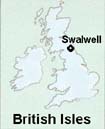
WHERE IS SWALWELL?Swalwell is in Tyneside in North East England and although in the Metropolitan Borough of Gateshead, remains within the County of Durham. Gateshead is one of the five boroughs in the 'new' County of Tyne and Wear, a new administrative county created in 1974 from parts of both Northumberland and Durham counties on either side of the River Tyne, and possessing its own County Council until 1986, when Tyne and Wear and the other Metropolitan County Councils were abolished, leaving the Metropolitan Boroughs as the basis for local administration. Swalwell is opposite to Newcastle upon Tyne and is about four miles from that city's centre. It is located almost one mile up river from the confluence of the Rivers Derwent and Tyne at Derwenthaugh. | Origins The location of Swalwell is shown on the map to the right. Note that the background colours of these web pages, yellow and blue, are based on the colours used in the emblem of County Durham. See Association of British Counties |
 |
LONG AGOIt is likely that the banks of the Rivers Tyne and Derwent were settled in pre-Roman times and certainly in the Roman period there were military and civilian settlements on the Tyne. Little is known of the period from the time the Romans left to early Saxon times, although the area was subject to Viking raids from Norway and Denmark and the Danes ruled parts of what is now northern England for long periods. Swalwell and the Tyneside area, that is the built-up area along the banks of the Tyne from the river mouth, were part of the ancient Kingdom of Northumbria which extended north from the River Humber to Edinburgh and the River Forth, while Bernicia was a Northumbrian province extending from Tees to Tweed. A weakened Northumbria was forced in 829 to accept the supremacy of Wessex which already incorporated Mercia under its rule, and resulted in England being united under one king. Periods of Danish rule followed.  The conquest of the Anglo-Saxons by the Normans, themselves of Viking descent, in 1066 did not immediately affect this area much, the North having been left largely to its own devices because of its remoteness and perceived relative lack of wealth and importance compared to the South of England. The savage retribution, the 'harrying of the north' as far as the Tees by King William, and the later punitive expedition by Odo of Bayeux, William's half-brother both of which followed rebellions against Norman rule in the decades up to 1100 were to change all this and bring the counties of Durham and Northumberland under stronger Norman domination when William's appointees, especially the Bishops of Durham, were given lands and political and religious power. William Rufus, king from 1087 completed this process. The The culture and the agricultural and social organisation of the area slowly changed and the Boldon Book* gives some indication of these changes and of land ownership at that time. Swalwell as a village did not then exist though, and it is difficult to state exactly when its formation began. The conquest of the Anglo-Saxons by the Normans, themselves of Viking descent, in 1066 did not immediately affect this area much, the North having been left largely to its own devices because of its remoteness and perceived relative lack of wealth and importance compared to the South of England. The savage retribution, the 'harrying of the north' as far as the Tees by King William, and the later punitive expedition by Odo of Bayeux, William's half-brother both of which followed rebellions against Norman rule in the decades up to 1100 were to change all this and bring the counties of Durham and Northumberland under stronger Norman domination when William's appointees, especially the Bishops of Durham, were given lands and political and religious power. William Rufus, king from 1087 completed this process. The The culture and the agricultural and social organisation of the area slowly changed and the Boldon Book* gives some indication of these changes and of land ownership at that time. Swalwell as a village did not then exist though, and it is difficult to state exactly when its formation began.
Back to top of page |
THE NAME OF SWALWELL
The name Swalwell probably comes from 'swale', a valley, and 'well', a spring, as there were several wells in the area. It is in the old Parish of Whickham and has been part of the Metropolitan Borough of Gateshead since 1974 before which it was part of Whickham Urban District. The earliest mention of Swalwell is in the Boldon Book* of 1183 when it may only have been a tiny settlement or simply part of someone's lands. An extract from the Boldon Book* reads 'The land of Swalwell renders 16s William, son of Swalwels Arnald, for a clearing of 120 acres, renders one mare'. Bourn's book, Whickham Parish, (1893), states that ,' in 1403-1404, William de Swalwells, burgess of Newcastle, released by charter all his lands and tenements to William Redmershall, of Newcastle. In 1411, William, son and heir of William de Swalwells, quit-claimed all his father's lands in Swalwell and Whickham to John Fenwyke, chaplain, a trustee for Roger Thornton.
Back to top of page |
Roger Thornton was a wealthy Newcastle merchant who was eight times mayor in the 15th century and whose monument is located in Newcastle Cathedral which he helped build. The Thornton brass was relocated from All Saints' and is one of the best in the country. His grandaughter carried her immense wealth into the family of Lumley. It afterwards passed to Matthew Ogle, gentleman, and again to a branch of the Lumleys; and in the year 1629, William Smith, of Durham, alienated the lands of Axwell and Swalwell to John Clavering, alderman of Newcastle, and James, his son, to whose family Swalwell has belonged since that time. 'In the time of Bishop Skirlaw, the Claxtons held lands in Swalwell, and a branch of this wealthy family probably lived here. Formerly a house stood at the west side of the present Wesleyan chapel, which was called Claxton Hall, the ruins of which were removed about seventy years ago'. (i.e., in about 1823). |
*The Boldon BookThe Domesday Book, a landholding record compiled in 1086 for William the Conqueror, showed who held what manor at that date, but omitted anything above the River Tees, including the counties of Northumberland and Durham. This was possibly because after the rising against Norman rule in 1080, and because of invasions from Scotland when the land was laid waste, Northumberland and Durham had been so ruthlessly devastated that they were hardly worth including. The Domesday Book records for several manors in the north simply read, 'It is waste'. An alternative view is that the region was too insecure for the Domesday commissioners compiling the survey, and that, since the purpose of the survey was to record what lands the king and his Norman conquerors owned and controlled, then because Northumberland and Durham were not yet (in 1086) fully conquered their inclusion would have been pointless and premature. (See Richard Lomas, North-East England In The Middle Ages, 1992.) In 1183, Hugh Pudsey, the then Bishop of Durham, compiled a survey of his lands known as the Boldon Book which covered much of the area of Northumberland and Durham. By that time Norman rule had become firmly established in the north. Boldon was taken by the surveyors as the standard type of manor, and the survey was thus named The Boldon Book. |
POPULATION, TOPOGRAPHY The population in 1811 was 1393, in 1831 - 1372, in 1851 - 1429, in 1891 - 2148 and in 1914 - 4000. The current population, including the recent housing developments, is estimated at about 3200 (2001 census figures plus an estimate for new housing since then).
In 1835 the Church of England commissioned a survey of the parish of Whickham and visits were made to every house noting the religious denomination, and sometimes a personal comment on the people surveyed. To view a sample page for Quality Row click here (for left hand side) and here (right hand side) Columns read from left to right, as follows; address, name, children (i.e.. S=son D=daughter L=lodger I=illegitimate, T=total, including husband and wife), occupation, and right hand page, religion (C=Church of England, M=Methodist), comments on religious characteristics of the family, i.e., R=regular attender at church, P=prayer book, B=Bible, S=Sacrament of the Lords supper and FP= Family Prayer, place of birth is then shown and finally any personal comments appeared in the last column. |
The village is bounded by the River  Derwent to the north which was in the past liable to flood its banks and low lying areas were flooded as recently as June 1966. The picture shows the river east of the Hikey Bridge. The northern part of the village is quite flat, but to the south of the main road it rises steeply towards Whickham, and its rows of terraced houses with their chimneys can be seen climbing up the hillside as in this early view of Axwell Terrace taken shortly after building. (see picture, left). Swalwell was for many years in the Parish of Whickham, that village being separated from Swalwell by an area called Middletown, largely green fields. This area is now however wholly built up and Middletown no longer exists though it was shown on Ordnance Survey maps as late as the 1950's. To the east the land rises over the fields towards Dunston, while to the southwest the Derwent Country Park follows the course of the river towards Winlaton Mill and beyond. Derwent to the north which was in the past liable to flood its banks and low lying areas were flooded as recently as June 1966. The picture shows the river east of the Hikey Bridge. The northern part of the village is quite flat, but to the south of the main road it rises steeply towards Whickham, and its rows of terraced houses with their chimneys can be seen climbing up the hillside as in this early view of Axwell Terrace taken shortly after building. (see picture, left). Swalwell was for many years in the Parish of Whickham, that village being separated from Swalwell by an area called Middletown, largely green fields. This area is now however wholly built up and Middletown no longer exists though it was shown on Ordnance Survey maps as late as the 1950's. To the east the land rises over the fields towards Dunston, while to the southwest the Derwent Country Park follows the course of the river towards Winlaton Mill and beyond. |
DERWENTHAUGH That part of Derwenthaugh lying to the west of the river Derwent did not belong to the Parish of Whickham, but to Blaydon. Bourn, in his history of the Parish of Ryton, describes Derwenthaugh as being one of the oldest villages in the North of England. The word Haugh means a meadow lying in a valley. Staiths have existed here since the early days of the coal owners of the 18th century, whose coal was transported by wagonway to Derwenthaugh for shipping. Bourn gives the origin of the term staith as coming from the Anglo-Saxon stathe, 'stade or steed', formerly applied to single fixed dwellings, or to places on the banks of rivers where merchandise was stored up, and at which vessels could lie to receive it'. Bourn continues, 'The staiths were afterwards provided with roofs, under which coals were deposited in bad seasons of trade, and with stages and spouts from which they are poured into keels when the demand for them was immediate'.
Coke ovens of the Stella Coal Company and Joseph Cowan existed here in the late 19th century on both the west and east sides, and both the Stella Coal Company and Joseph Cowen also had a staith here, as did the Consett Iron Company. A guano works and a bone mill once flourished here too. A row of houses with the Skiff Inn at one end once existed at Derwenthaugh, and famed oarsman (and boatbuilder) Harry Clasper once lived and worked here. Back to top of page Previous........Next |